Case Studies on the Application of Mobile Data Collection in Statistics and Planning
The following are real-world examples of the transformative impact of mobile data collection in statistics and planning:
1. Hoji For Data Collection in 2019 Kenya National Census – The Kenya National Bureau of Statistics (KNBS)
Kenya Population and Housing Census is a nationwide count of every person and household in Kenya, conducted every 10 years.
The census is vital in collecting comprehensive demographic, social, and economic data about the country.
Kenya first conducted a census program in 1948, with subsequent counts in 1962 and 1969, before establishing the regular 10-year intervals.
Project Details
- The 2019 Kenya National Population and Housing Census was historic marking the first time the country used digital tools for data collection.
- The census was conducted by the Kenya National Bureau of Statistics (KNBS), a state corporation under the Ministry of Treasury and Planning.
- Hoji, a popular mobile data collection tool was introduced to streamline the exercise by replacing traditional paper-based methods with Electronic Data Collection (EDC).
- Hoji’s digital platform was used to train enumerators to conduct the census on tablets rather than traditional paper forms.
- Enumerators visited households and recorded responses on a digital questionnaire, which included personal, household, and demographic details, providing accurate and up-to-date information.
- This new approach ensured that data was captured electronically and directly synced to central databases for immediate processing.
Challenges Before the Adoption of Mobile Data Collection in Kenya’s Census Cycles
- Paper-based forms were prone to errors and inconsistencies.
- Manual data entry and processing delayed census results.
- Managing a nationwide paper-based survey required extensive resources and posed challenges in remote areas.

Kenya held censuses in 1948, 1962, and 1969 before adopting its current 10-year census schedule. Picture/Courtesy
Key Benefits After the Adoption of Mobile Data Collection
Government agencies, policymakers, and local communities were positively impacted by the digital census in the following ways:
- The risk of human error was significantly reduced, resulting in more reliable and accurate data.
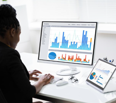
- Real-time data upload enabled quicker analysis and reporting, allowing faster insights for decision-makers.
- The digital method minimized the need for large volumes of paper and physical storage, leading to reduced costs and faster completion of the census.
- The public and stakeholders could easily access census data, promoting transparency and facilitating future planning.
Source
Kenya Goes Digital With the 2019 Population and Housing Census! – Hoji.co.ke
2. Drones in 3D Mapping and Urban Planning for Weinan City, China
Weinan is a prefecture-level city (Chinese administrative level) located in the east-central region of Shaanxi province, in northwest China.
Weinan is located close to Mount Hua, one of China’s Five Great Mountains, a significant tourist attraction.
Project Details
- In 2016, the Weinan Municipal Government launched the Weinan Xueliang Project aimed at improving urban public security and optimizing city planning through advanced technological solutions.
- The Weinan Municipality sought to improve urban infrastructure, public safety, and governance, impacting areas such as residential neighborhoods, commercial streets, transportation hubs, and schools.
- Weinan adopted drone-based 3D mapping to create a high-fidelity digital model of Weinan city.
- JOUAV CW-15 VTOL drone and PH-7E multi-rotor drones were deployed for the project.
- The drones were equipped with CA-503R oblique cameras, and captured images from multiple angles, producing a comprehensive, accurate 3D model.
Challenges Before the Adoption of Drones in Urban Planning
The 150-square-kilometer area needed to be mapped in just 30 days, a timeline that traditional surveying methods could not meet.

3D models from drones have high-level accuracy, providing highly detailed data useful for urban planning and smart city development. Picture/Courtesy
Key Benefits After the Adoption of Drone Technology in Urban Planning
- Drones completed the mapping of a 150-square-kilometer area within 6 days, far exceeding the initial 30-day expectation.
- The 3D model had high-level accuracy, providing highly detailed data useful for urban planning and smart city development.
- Drone-based data collection reduced expensive manual labor requirements and field surveys, saving both time and money.
- The 3D model allowed urban planners to visualize infrastructure layouts accurately, avoiding costly mistakes during the city development design process.
Sources
- Drone 3D Mapping Improves Urban Planning & Smart Cities in Weinan – Jouav
- The Impact and Efficiency of Drones for Survey and Mapping – TerraDrone Arabia
3. Dimagi CommCare For Improving and Monitoring Community Health in Guatemala – TulaSalud
Guatemala, in Central America, is famous for its ancient Mayan sites and beautiful natural features, such as many volcanos and Lake Atitlan.
However, rural and underserved communities in the country face significant health challenges due to limited access to medical resources, lack of infrastructure, and high rates of preventable diseases.
Poverty and a lack of health services contribute to extremely high maternal mortality rates in Guatemala’s northern highlands.
NGOs such as TulaSalud have intensified efforts to bridge the healthcare gaps that continue to threaten lives in the area.
Project Details
- In 2017, TulaSalud rolled out a digital health program for frontline health workers in Northern Guatemala to help address maternal health challenges.
- The project leveraged Dimagi CommCare, a mobile data collection and management tool, to streamline data collection for planning purposes.
- TulaSalud partnered with other organizations including the Tula Foundation and the Guatemalan Ministry of Health.
Challenges Before the Adoption of Mobile Data Collection in Guatemala’s Health Campaigns
- Health workers, particularly community health promoters, used paper-based methods for data collection. This approach was prone to errors, data loss, and delays in reporting.
- Public health data collection was difficult due to logistical challenges in remote areas and the lack of coordination among different stakeholders.
- Lack of real-time patient data among doctors and community health personnel delayed informed healthcare decisions.

Chichicastenango is a town in the Guatemalan highlands northwest of Guatemala City, known for its open-air craft market and indigenous Maya culture. Picture/Courtesy
Key Benefits After the Adoption of Dimagi CommCare in Northern Guatemala
- CommCare enabled community health workers to collect health data directly on mobile devices, replacing the paper-based system. This helped eliminate errors associated with manual data entry.
- The system allowed field workers to submit data directly to central databases, enabling health authorities to monitor health conditions and plan interventions on time.
- Health data collected through CommCare could be analyzed to identify trends, track health outcomes, and inform public health interventions.
- By ensuring that individuals received timely care and follow-ups, the project contributed to improved health outcomes.
Source
TulaSalud: CommCare for Improving and Monitoring Community Health – Dimagi
4. ELMO Open Source Mobile Data Collection Tool: Planning and Observation of Democratic Elections – Carter Center
The Carter Center, founded in 1982 by former U.S. President Jimmy Carter and his wife Rosalynn, is a non-governmental, non-profit organization dedicated to advancing human rights and alleviating human suffering worldwide.
The Carter Center also runs the Democratic Election Standards project to create agreement on democratic election requirements and evaluation methods.
Under this project, the Carter Center has observed several elections worldwide, collecting data and views from stakeholders on how best to cultivate democratic processes.
Project Details
- The Carter Center has previously observed elections in Tunisia under the Democratic Election Standards.
- Tunisia’s 2014 and 2019 parliamentary and presidential elections marked significant milestones in the country’s democratic transition after the 2011 revolution.
- For election monitoring, the Carter Center employed ELMO, a technology designed for election logistics and data collection.
- The collected data was then integrated into the Democratic Election Standards project to inform future elections around the world.
- The tool was officially adopted by the Carter Center in collaboration with the Independent High Authority for Elections (ISIE) in 2014 before its improved version was used in 2019.
- ELMO allows election observers to submit evaluations of an electoral process using checklists in real time to mission headquarters.
- ELMO’s interface draws several similarities with other mobile data collection tools such as ODK, a popular open-source set of tools for collecting data in remote locations.
Challenges Before the Adoption of Mobile Data Collection in Election Monitoring
- Election observers were primarily using manual methods such as paper forms and handwritten reports, which were slow and prone to errors.
- The absence of an effective system for monitoring election activities in real-time raised concerns about transparency and accountability.
- With a large and geographically diverse electorate, monitoring the election process across Tunisia was challenging.
- Without modern technological tools, there was a delay in analyzing and responding to issues on election day.

A statue of former US President Jimmy Carter, the founder of the Carter Center, on the grounds of the Georgia State Capitol. Picture/Courtesy
Key Benefits After Adoption of Mobile Data Collection
- ELMO’s real-time data collection and public access features ensured that all stakeholders had access to consistent, up-to-date information.
- Election observers could submit their reports instantly, reducing data entry errors and improving the speed of report consolidation.
- ELMO facilitated better coordination between election observers, local authorities, and the Independent High Authority for Elections (ISIE).
- The system allowed for more sophisticated analysis of election data, including monitoring trends in voter turnout, the frequency of irregularities, and polling station conditions.
- Political parties and civil societies accessed real-time data, providing them with the information needed to monitor the election and hold the process accountable.
Sources
- ELMO in Action: Carter Center Leads in Election Technology – The Carter Center
- The Democratic Election Standards project – The Carter Center
- ELMO – The Carter Center
5. Using ODK to Improve Data Quality at Health Facilities in Rural Malawi – University of California, San Francisco (UCSF)
In rural Malawi, healthcare data management was a major challenge due to poor infrastructure, manual data collection methods, and limited access to modern technology.
Health facilities in these areas struggle with maintaining accurate patient records, monitoring health outcomes, and effectively reporting data to health authorities.
Project Details
- ODK was adopted in 2018 as part of a broader initiative to enhance healthcare services and improve data accuracy across Malawi’s rural health sector.
- The project was primarily funded through international development organizations, with key support from the United Nations Development Programme (UNDP) and USAID.
- University of California, San Francisco (UCSF) in collaboration with the Malawi Ministry of Health executed the project.
- It was part of broader initiatives aimed at improving healthcare data collection and management in rural settings.
Challenges Before the Adoption of Mobile Data Collection
- Health workers relied on paper-based forms to collect patient data, which were then manually transcribed into databases.
- The manual system was highly vulnerable to data loss, particularly in rural areas where paper records could be misplaced, damaged, or destroyed.
- The paper-based reporting process was slow, with health facilities often missing deadlines for submitting health data to government health authorities.
- Health managers and policymakers had limited access to real-time data from the health facilities, making it difficult to track health trends, monitor outbreaks, or assess the quality of services.

Lunch is served at a rural village in Malawi. These underserved areas have historically suffered from inadequate health services. Picture/Courtesy
Key Benefits After the Adoption of Mobile Data Collection
- By replacing manual paper-based forms with digital data collection, the system significantly reduced errors and data inconsistencies.
- Digital data collection minimized the risk of data loss due to physical damage or misplacement of paper records.
- The real-time data synchronization allowed for faster reporting to health authorities, enabling them to make timely decisions about resource allocation.
- Supervisors could monitor the progress of data collection in real-time, identify any issues or gaps, and provide immediate feedback.
- Improved data accuracy and faster reporting meant better healthcare decision-making and faster response times, which contributed to better health outcomes for patients.
Source
Leveraging phone-based mobile technology to improve data quality at health facilities in rural Malawi: a best practice project – National Library of Medicine