
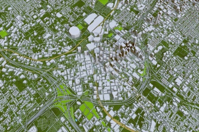
LiDAR for Advanced Spatial Analysis: Data Processing and 3D Modeling Training Course
This training course will equip participants with the necessary skills and knowledge on how to report, analyze, and disseminate data for all health programs.






Course Overview
| Course Title | LiDAR for Advanced Spatial Analysis: Data Processing and 3D Modeling Training Course |
| Organization | Tech For Development (T4D) |
| Venue | Tech For Development (T4D) Training Center along Tala Road, Runda, Nairobi |
| Duration | 5 days |
| Target Industries |
|
| Target Job Roles |
|
| Course Fees (Face-to-Face) | USD 1,100/KES 75,000 (Exclusive of VAT) |
| Course Fees (Virtual) | USD 1,000/KES 70,000 (Exclusive of VAT) |
| Training Modes | Virtual and face-to-face training |
| Payment | Payment should be made to the Tech For Development (T4D) bank account on or before the start of the course |
| Accreditation | Tech For Development Certificate of Course Completion |
Course Overview:
This 5-day training course, offered by IRES, is designed to provide participants with advanced skills in LiDAR data processing and 3D modeling. The course covers comprehensive techniques for analyzing LiDAR data, creating detailed 3D models, and applying these models to various spatial analysis tasks. Participants will gain hands-on experience with cutting-edge tools and software to effectively manage, process, and visualize LiDAR data for diverse applications. The course includes real-world projects and case studies to ensure practical understanding and application of the concepts.
Course Duration:
5 days
Target Audience:
- GIS professionals and spatial analysts
- Remote sensing specialists
- Environmental scientists and land surveyors
- Urban planners and infrastructure developers
- Researchers involved in spatial analysis and 3D modeling
Personal Impact:
- Acquire advanced skills in processing and analyzing LiDAR data.
- Learn to create detailed 3D models from LiDAR datasets.
- Develop expertise in applying LiDAR data to various spatial analysis scenarios.
- Enhance your ability to visualize and interpret complex spatial information.
- Improve your contribution to projects requiring high-precision spatial data analysis.
Organizational Impact:
- Enhance the organization’s capability in managing and analyzing LiDAR data.
- Support advanced spatial analysis and decision-making with detailed 3D models.
- Improve project outcomes through effective use of LiDAR data and 3D visualization.
- Foster innovation in spatial data analysis and modeling within the organization.
- Strengthen the organization's expertise in cutting-edge LiDAR technology.
Course Objectives:
- To provide a thorough understanding of LiDAR data processing techniques.
- To teach participants how to create and use 3D models derived from LiDAR data.
- To equip participants with skills for advanced spatial analysis using LiDAR data.
- To demonstrate practical applications of LiDAR data in real-world scenarios.
- To enable participants to complete hands-on projects involving LiDAR data and 3D modeling.
Course Modules
Course Outline:
Module 1: Introduction to LiDAR Data and Technology
- Overview of LiDAR technology and principles
- Types of LiDAR systems and their applications
- Basics of LiDAR data acquisition and processing
- Case Study: Applications of LiDAR in environmental monitoring and urban planning
Module 2: LiDAR Data Processing Techniques
- Pre-processing and quality control of LiDAR data
- Techniques for filtering and classifying LiDAR point clouds
- Methods for extracting features and information from LiDAR data
- Real-Life Project: Processing and filtering LiDAR data to extract key features
Module 3: Creating 3D Models from LiDAR Data
- Techniques for generating 3D models from LiDAR point clouds
- Methods for enhancing 3D model accuracy and detail
- Visualization and interpretation of 3D models
- Case Study: Developing a 3D model of an urban area using LiDAR data
Module 4: Advanced Spatial Analysis with LiDAR
- Spatial analysis techniques for LiDAR data
- Integrating LiDAR data with other spatial datasets
- Applications of LiDAR in various fields (e.g., forestry, flood modeling)
- Real-Life Project: Applying LiDAR data to a complex spatial analysis scenario
Module 5: Communicating LiDAR Analysis Results and Findings
- Best practices for presenting LiDAR data and 3D models
- Techniques for creating effective visualizations and reports
- Addressing challenges in communicating LiDAR information to stakeholders
- Case Study: Preparing and presenting a report on LiDAR analysis results for a high-profile project
Course Administration
Methodology
Instructor-led sessions use a blended learning approach combining presentations, guided practical exercises, web-based tutorials, and group work, delivered by seasoned industry experts. All facilitation and course materials are in English, so participants should be reasonably proficient in the language.
Accreditation
Upon successful completion of this training, participants will be issued a Tech For Development Certificate of Course Completion certified by the National Industrial Training Authority (NITA).
Training Venue
The training will be held at the Tech For Development Training Centre. The course fee covers the course tuition, training materials, two break refreshments, and lunch. All participants will additionally cater to their travel expenses, visa application, insurance, and other personal expenses.
Accommodation & Airport Transfer
Arranged upon request.For reservations contact the Training Officer:
Email: [email protected]
Phone: (+254) 790 824 179
Tailor-Made
This training can also be customized to suit the needs of your institution upon request. You can have it delivered in our T4D Training Centre or at a convenient location.
Payment
Payment should be transferred to the T4D account through a bank on or before the start of the course. Send proof of payment to [email protected].
Related Courses


Course Reviews
Based on 0 participant feedback
No reviews yet for this course. Be the first to share your experience!
Write a Course Review
Please share your honest feedback below.